Geolocate

Haralson topographic map

Click on the map to display elevation.

About this map

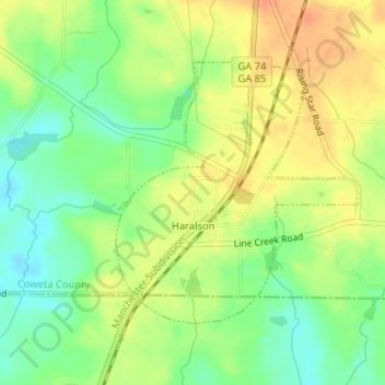
Name: Haralson topographic map, elevation, terrain.

Location: Haralson, Coweta County, Georgia, 30229, United States (33.21967 -84.57780 33.23799 -84.55744)

Average elevation: 250 m

Minimum elevation: 229 m

Maximum elevation: 268 m

Other topographic maps

Click on a map to view its topography, its elevation and its terrain.

East Newnan

United States > Georgia > Coweta County

Average elevation: 290 m

Arnco Mills

United States > Georgia > Coweta County

Average elevation: 256 m

McBride

United States > Georgia > Coweta County > Newnan

Average elevation: 280 m

McCollum

United States > Georgia > Coweta County

Average elevation: 284 m

Gear up for your next adventure:

🧥Waterproof Pants - Keep dry during rainy hiking conditions
🚲Bike Repair Kit - Essential tools for on-trail mechanical issues
❄️Traction Ice Cleats - Slip-on spikes for icy trails and winter hiking
🧦Thermal Socks - Warm socks for winter hiking or camping
🧣Evaporative Cooling Towel - Beat the heat during intense summer climbs

As an Amazon Associate, this site earns from qualifying purchases at no extra cost to you.