Geolocate

Mount Sibayak topographic map

Click on the map to display elevation.

About this map

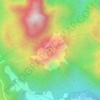
Name: Mount Sibayak topographic map, elevation, terrain.

Location: Mount Sibayak, Karo, North Sumatra, Sumatra, 22156, Indonesia (3.23930 98.50471 3.23940 98.50481)

Average elevation: 1,755 m

Minimum elevation: 1,368 m

Maximum elevation: 2,179 m

Other topographic maps

Click on a map to view its topography, its elevation and its terrain.

Berastagi

Indonesia > North Sumatra > Karo

Average elevation: 1,418 m

Gear up for your next adventure:

💧Reusable Water Bottle - Durable water bottles for hydration on trails
🥾Light Trekking Boots - Supportive boots for multi-day treks
🎒Fully Waterproof Backpack - Total protection for photography gear and electronics
🛌Down Sleeping Bag - Superior warmth-to-weight ratio for cold nights
🚲Bike Repair Kit - Essential tools for on-trail mechanical issues

As an Amazon Associate, this site earns from qualifying purchases at no extra cost to you.