
Thank you for supporting this site ❤️
Make a donation
Make a donation
Gear up for your next adventure:
As an Amazon Associate, this site earns from qualifying purchases at no extra cost to you.
گوملا topographic map
Click on the map to display elevation.
Thank you for supporting this site ❤️
Make a donation
Make a donation
Gear up for your next adventure:
As an Amazon Associate, this site earns from qualifying purchases at no extra cost to you.
About this map
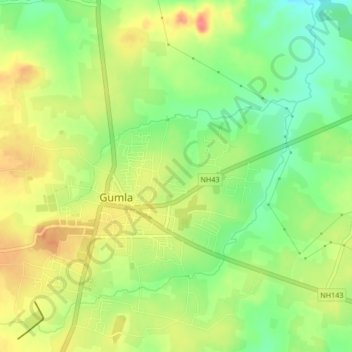
Name: گوملا topographic map, elevation, terrain.
Location: گوملا, Gumla, Gumla District, Jharkhand, 835200, India (23.03212 84.52335 23.05764 84.56498)
Average elevation: 640 m
Minimum elevation: 608 m
Maximum elevation: 673 m
Thank you for supporting this site ❤️
Make a donation
Make a donation
Gear up for your next adventure:
As an Amazon Associate, this site earns from qualifying purchases at no extra cost to you.