
Thank you for supporting this site ❤️
Make a donation
Make a donation
Gear up for your next adventure:
As an Amazon Associate, this site earns from qualifying purchases at no extra cost to you.
Washburn topographic map
Click on the map to display elevation.
Thank you for supporting this site ❤️
Make a donation
Make a donation
Gear up for your next adventure:
As an Amazon Associate, this site earns from qualifying purchases at no extra cost to you.
About this map
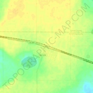
Name: Washburn topographic map, elevation, terrain.
Location: Washburn, Armstrong County, Texas, United States (35.15672 -101.59323 35.19672 -101.55323)
Average elevation: 1,075 m
Minimum elevation: 1,059 m
Maximum elevation: 1,082 m
Thank you for supporting this site ❤️
Make a donation
Make a donation
Gear up for your next adventure:
As an Amazon Associate, this site earns from qualifying purchases at no extra cost to you.
Other topographic maps
Click on a map to view its topography, its elevation and its terrain.
Palo Duro Canyon State Park
United States > Texas > Armstrong County > Timbercreek Canyon
Average elevation: 980 m