
West Poland topographic map
Interactive map
Click on the map to display elevation.
About this map
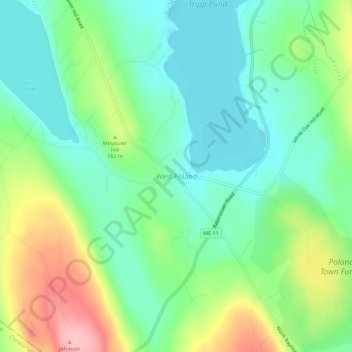
Name: West Poland topographic map, elevation, terrain.
Average elevation: 137 m
Minimum elevation: 88 m
Maximum elevation: 236 m
Other topographic maps
Click on a map to view its topography, its elevation and its terrain.
East Poland
United States > Maine > Androscoggin County > Poland
East Poland, Poland, Androscoggin County, Maine, 04274, United States
Average elevation: 87 m
Upper Range Pond
United States > Maine > Androscoggin County > Poland
Upper Range Pond, Poland, Androscoggin County, Maine, United States
Average elevation: 119 m