Geolocate

Anaconda topographic map

Click on the map to display elevation.

About this map

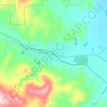
Name: Anaconda topographic map, elevation, terrain.

Location: Anaconda, Deer Lodge County, Montana, 59711, United States (46.08947 -112.99313 46.16947 -112.91313)

Average elevation: 1,753 m

Minimum elevation: 1,540 m

Maximum elevation: 2,359 m

Other topographic maps

Click on a map to view its topography, its elevation and its terrain.

Silver Lake

United States > Montana > Deer Lodge County

Average elevation: 2,029 m

Gear up for your next adventure:

🥘Camping Cookware Set - Compact nesting pots and pans for trail cooking
🛶Waterproof Dry Bags - Keep electronics and clothes dry during river crossings
🚑Survival Whistle - Signal for help across long distances in mountains
🪑Insulated Seat Pad - Protect your seat from cold rocks and wet logs
🥾Trail Hiking Shoes - Durable shoes designed for rugged trails

As an Amazon Associate, this site earns from qualifying purchases at no extra cost to you.