
Make a donation
Gear up for your next adventure:
As an Amazon Associate, this site earns from qualifying purchases at no extra cost to you.
Ponmudi topographic map
Click on the map to display elevation.
Make a donation
Gear up for your next adventure:
As an Amazon Associate, this site earns from qualifying purchases at no extra cost to you.
Ponmudi
Ponmudi (the Golden Peak) is a hill station in the Peringamala gramapanchayath of Thiruvananthapuram district of Kerala in India. It is located 22km west of Vithura town, 53 km north-east of Thiruvananthapuram City, 78 km south-east of Varkala town and 69 km north-east of Kovalam Beach at an altitude of 1,100 m (3,600 ft). Ponmudi (Varayadumotta) peak is a part of the Western Ghats mountain range that runs parallel to the Arabian Sea. Ponmudi is a popular honeymoon destination in South India. The normal temperature of Ponmudi is between 18 and 25 °C (64 and 77 °F).
Make a donation
Gear up for your next adventure:
As an Amazon Associate, this site earns from qualifying purchases at no extra cost to you.
About this map
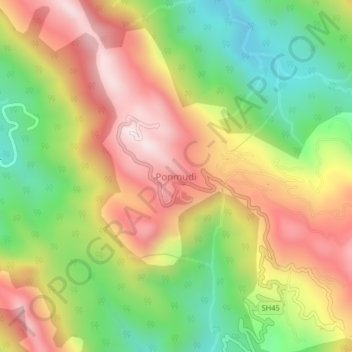
Name: Ponmudi topographic map, elevation, terrain.
Location: Ponmudi, Nedumangad, Thiruvananthapuram, Kerala, India (8.74000 77.09500 8.78000 77.13500)
Average elevation: 673 m
Minimum elevation: 290 m
Maximum elevation: 1,071 m
Make a donation
Gear up for your next adventure:
As an Amazon Associate, this site earns from qualifying purchases at no extra cost to you.