
Make a donation
Gear up for your next adventure:
As an Amazon Associate, this site earns from qualifying purchases at no extra cost to you.
De Hoop Nature Reserve topographic map
Click on the map to display elevation.
Make a donation
Gear up for your next adventure:
As an Amazon Associate, this site earns from qualifying purchases at no extra cost to you.
About this map
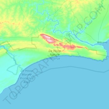
Name: De Hoop Nature Reserve topographic map, elevation, terrain.
Average elevation: 63 m
Minimum elevation: -2 m
Maximum elevation: 581 m
Make a donation
Gear up for your next adventure:
As an Amazon Associate, this site earns from qualifying purchases at no extra cost to you.
Other topographic maps
Click on a map to view its topography, its elevation and its terrain.
Hermanus
South Africa > Western Cape > Overberg District Municipality > Overstrand Local Municipality
Average elevation: 87 m
Stanford
South Africa > Western Cape > Overberg District Municipality > Overstrand Local Municipality
Average elevation: 107 m
Riviersonderend
South Africa > Western Cape > Overberg District Municipality > Theewaterskloof Local Municipality
Average elevation: 212 m
Onrus River
South Africa > Western Cape > Overberg District Municipality > Overstrand Local Municipality
Average elevation: 232 m
Make a donation
Gear up for your next adventure:
As an Amazon Associate, this site earns from qualifying purchases at no extra cost to you.
Hawston
South Africa > Western Cape > Overberg District Municipality > Overstrand Local Municipality
Average elevation: 59 m
Dyer Island
South Africa > Western Cape > Overberg District Municipality > Overstrand Local Municipality
Average elevation: 0 m
Geyser Island
South Africa > Western Cape > Overberg District Municipality > Overstrand Local Municipality
Average elevation: 0 m
Grabouw
South Africa > Western Cape > Overberg District Municipality > Theewaterskloof Local Municipality
The Elgin valley is South Africa's coolest climate wine-growing region and a range of other geographic factors (for example, its proximity to the Atlantic Ocean, cool temperatures, plentiful winter rainfall, prevailing wind directions, and altitude) have created a set of conditions for wine growing which are…
Average elevation: 358 m
Make a donation
Gear up for your next adventure:
As an Amazon Associate, this site earns from qualifying purchases at no extra cost to you.
Caledon
South Africa > Western Cape > Overberg District Municipality > Theewaterskloof Local Municipality
Average elevation: 311 m
Pringle Bay
South Africa > Western Cape > Overberg District Municipality > Overstrand Local Municipality
Average elevation: 62 m
Salt River
South Africa > Western Cape > Overberg District Municipality > Theewaterskloof Local Municipality
Average elevation: 240 m
Mooiuitsig
South Africa > Western Cape > Overberg District Municipality > Overstrand Local Municipality
Average elevation: 173 m
Make a donation
Gear up for your next adventure:
As an Amazon Associate, this site earns from qualifying purchases at no extra cost to you.