
Make a donation
Gear up for your next adventure:
As an Amazon Associate, this site earns from qualifying purchases at no extra cost to you.
Flesten topographic map
Click on the map to display elevation.
Make a donation
Gear up for your next adventure:
As an Amazon Associate, this site earns from qualifying purchases at no extra cost to you.
About this map
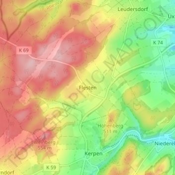
Name: Flesten topographic map, elevation, terrain.
Average elevation: 486 m
Minimum elevation: 399 m
Maximum elevation: 564 m
Make a donation
Gear up for your next adventure:
As an Amazon Associate, this site earns from qualifying purchases at no extra cost to you.
Other topographic maps
Click on a map to view its topography, its elevation and its terrain.
Kerpen (Eifel)
Deutschland > Rheinland-Pfalz > Landkreis Vulkaneifel
Zur Gemeinde Kerpen (Eifel) gehören die Ortsteile Kerpen mit dem Bernardyshof und Loogh mit der Looghermühle. Der Ortsteil Kerpen liegt auf ca. 430 m ü. NHN im Naturpark Vulkaneifel im Ostteil der Hillesheimer Kalkmulde im Tal des Rudersbaches, am Dolomitsporn des Höhenberges (⊙50.3172976.735358511.1…
Average elevation: 481 m