Geolocate

Pic de Finestrelles topographic map

Click on the map to display elevation.

Pic de Finestrelles

Pic de Finestrelles is a mountain located in the Oriental Pyrenees, on the border of France and Spain. It has an altitude of 2,826 metres (9,272 ft) above sea level.

Wikipedia (CC-BY-SA 3.0)

About this map

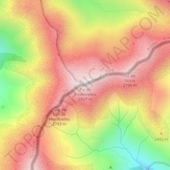
Name: Pic de Finestrelles topographic map, elevation, terrain.

Location: Pic de Finestrelles, Eyne, Prades, Pyrénées-Orientales, Occitania, Metropolitan France, 66800, France (42.41438 2.13342 42.41448 2.13352)

Average elevation: 2,502 m

Minimum elevation: 2,027 m

Maximum elevation: 2,823 m

Gear up for your next adventure:

Camping Tent - Weather-resistant tents suitable for 2 to 6 people
🛏️Camping Sleeping Mat - Comfortable mats for sleeping outdoors
🔭Compact Monocular - One-handed bird watching and trail spotting
🧢Beanie Hat - Keep your head warm in cold weather
💡LED Camping Lantern - Illuminate your campsite with long-lasting lanterns

As an Amazon Associate, this site earns from qualifying purchases at no extra cost to you.