
Huaral topographic map
Interactive map
Click on the map to display elevation.
About this map
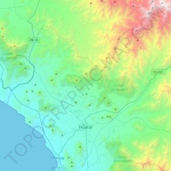
Name: Huaral topographic map, elevation, terrain.
Location: Huaral, Provincia de Huaral, Lima, Perú (-11.56355 -77.33299 -11.24546 -76.95181)
Average elevation: 618 m
Minimum elevation: -1 m
Maximum elevation: 2,870 m
Other topographic maps
Click on a map to view its topography, its elevation and its terrain.
Río Chancay
Río Chancay, Huaral, Provincia de Huaral, Lima, Perú
Average elevation: 1,092 m
Jesús del Valle
Perú > Lima > Huaral > Jesús del Valle
Jesús del Valle, Huaral, Provincia de Huaral, Lima, Perú
Average elevation: 185 m