Geolocate

Griffen topographic map

Click on the map to display elevation.

About this map

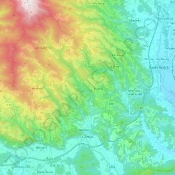
Name: Griffen topographic map, elevation, terrain.

Location: Griffen, Bezirk Völkermarkt, Carinthia, 9112, Austria (46.66986 14.64632 46.82610 14.80632)

Average elevation: 793 m

Minimum elevation: 386 m

Maximum elevation: 1,892 m

Gear up for your next adventure:

🧥Waterproof Hiking Jacket - Protect yourself from rain and wind while hiking
🎒Fully Waterproof Backpack - Total protection for photography gear and electronics
🧢Outdoor Cap - Protective cap for sun and rain during hikes
🔦LED Headtorch - Bright and durable light for night activities
🥾Approach Shoes - Shoes designed for climbing approaches and rugged trails

As an Amazon Associate, this site earns from qualifying purchases at no extra cost to you.