
Chilliwack topographic map
Click on the map to display elevation.
About this map
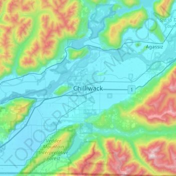
Name: Chilliwack topographic map, elevation, terrain.
Average elevation: 381 m
Minimum elevation: -1 m
Maximum elevation: 1,986 m
Fraser Valley Regional District trails, hiking, mountain biking, running and outdoor activities
Other topographic maps
Click on a map to view its topography, its elevation and its terrain.
Area A (Boston Bar/North Bend/Canyon Alpine)
Canada > British Columbia > Fraser Valley Regional District
Average elevation: 1,260 m
Mission
Canada > British Columbia > Fraser Valley Regional District
The western part of the district, the Stave Valley, is largely rural and forested but its watercourse is home to what was the largest hydroelectric project in British Columbia until the Bridge River Power Project opened in 1961. It was built by the British Columbia Electric Railway (BCER) to provide power to…
Average elevation: 345 m
Chilliwack Lake
Canada > British Columbia > Fraser Valley Regional District > Area E (Chilliwack River Valley)
Average elevation: 1,152 m
Cultus Lake
Canada > British Columbia > Fraser Valley Regional District > Area H (Cultus Lake/Columbia Valley) > Cultus Lake
Average elevation: 191 m
Harrison Hot Springs
Canada > British Columbia > Fraser Valley Regional District
Average elevation: 203 m
Area E (Chilliwack River Valley)
Canada > British Columbia > Fraser Valley Regional District
Average elevation: 1,032 m
Harrison Lake
Canada > British Columbia > Fraser Valley Regional District > Area C (Sasquatch Country)
Average elevation: 815 m
Area H (Cultus Lake/Columbia Valley)
Canada > British Columbia > Fraser Valley Regional District
Average elevation: 566 m
Harrison River
Canada > British Columbia > Fraser Valley Regional District > Kent > Harrison Mills
Average elevation: 45 m
Sumas River
Canada > British Columbia > Fraser Valley Regional District > Abbotsford
Average elevation: 167 m
Stave Lake
Canada > British Columbia > Fraser Valley Regional District > Mission
Average elevation: 573 m
Chehalis Lake
Canada > British Columbia > Fraser Valley Regional District > Area C (Sasquatch Country)
Average elevation: 735 m
Glacier Lake
Canada > British Columbia > Fraser Valley Regional District > Area C (Sasquatch Country)
Average elevation: 614 m
Sloquet Creek
Canada > British Columbia > Fraser Valley Regional District > Area C (Sasquatch Country)
Average elevation: 255 m
Campbell Lake
Canada > British Columbia > Fraser Valley Regional District > Kent
Average elevation: 528 m
Area F (McConnell Creek/Hatzic Prairie)
Canada > British Columbia > Fraser Valley Regional District
Average elevation: 832 m
Falls Lake
Canada > British Columbia > Fraser Valley Regional District > Area B (South Fraser Canyon/Sunshine Valley)
Average elevation: 1,512 m
Jones Lake
Canada > British Columbia > Fraser Valley Regional District > Area D (Popkum/Bridal Falls/Wahleach)
Average elevation: 956 m
Stoney Creek Park
Canada > British Columbia > Fraser Valley Regional District > Abbotsford
Average elevation: 40 m
Hicks Lake
Canada > British Columbia > Fraser Valley Regional District > Kent
Average elevation: 377 m
Area B (South Fraser Canyon/Sunshine Valley)
Canada > British Columbia > Fraser Valley Regional District
Average elevation: 1,174 m
Sumas Prairie
Canada > British Columbia > Fraser Valley Regional District > Abbotsford
Average elevation: 159 m
Serpentine Lake
Canada > British Columbia > Fraser Valley Regional District > Area B (South Fraser Canyon/Sunshine Valley)
Average elevation: 960 m
Isabel Lake
Canada > British Columbia > Fraser Valley Regional District > Area F (McConnell Creek/Hatzic Prairie)
Average elevation: 687 m
Vedder River
Canada > British Columbia > Fraser Valley Regional District > Chilliwack
Average elevation: 110 m
Area C (Sasquatch Country)
Canada > British Columbia > Fraser Valley Regional District
Average elevation: 988 m
Chehalis River
Canada > British Columbia > Fraser Valley Regional District > Area C (Sasquatch Country)
Average elevation: 424 m
Misty Icefield
Canada > British Columbia > Fraser Valley Regional District > Area F (McConnell Creek/Hatzic Prairie)
Average elevation: 1,800 m
Mamquam Icefield
Canada > British Columbia > Fraser Valley Regional District > Area F (McConnell Creek/Hatzic Prairie)
Average elevation: 1,925 m
Hope Slide
Canada > British Columbia > Fraser Valley Regional District > Area B (South Fraser Canyon/Sunshine Valley)
Average elevation: 1,160 m
Area G (Deroche/Dewdney/Sumas Mountain)
Canada > British Columbia > Fraser Valley Regional District > Area G (Deroche/Dewdney/Sumas Mountain)
Average elevation: 211 m
Area C (Sasquatch Country)
Canada > British Columbia > Fraser Valley Regional District
Average elevation: 988 m
Mission
Canada > British Columbia > Fraser Valley Regional District
The western part of the district, the Stave Valley, is largely rural and forested but its watercourse is home to what was the largest hydroelectric project in British Columbia until the Bridge River Power Project opened in 1961. It was built by the British Columbia Electric Railway (BCER) to provide power to…
Average elevation: 345 m
Sumas Prairie
Canada > British Columbia > Fraser Valley Regional District > Abbotsford
Average elevation: 159 m
Area D (Popkum/Bridal Falls/Wahleach)
Canada > British Columbia > Fraser Valley Regional District
Average elevation: 948 m
Area B (South Fraser Canyon/Sunshine Valley)
Canada > British Columbia > Fraser Valley Regional District
Average elevation: 1,174 m
Mission
Canada > British Columbia > Fraser Valley Regional District
The western part of the district, the Stave Valley, is largely rural and forested but its watercourse is home to what was the largest hydroelectric project in British Columbia until the Bridge River Power Project opened in 1961. It was built by the British Columbia Electric Railway (BCER) to provide power to…
Average elevation: 345 m
Turner Glacier
Canada > British Columbia > Fraser Valley Regional District > Area C (Sasquatch Country)
Average elevation: 2,183 m
Ryder Lake
Canada > British Columbia > Fraser Valley Regional District > Chilliwack
Average elevation: 255 m
Area D (Popkum/Bridal Falls/Wahleach)
Canada > British Columbia > Fraser Valley Regional District
Average elevation: 948 m
Harrison-Chehalis Wildlife Management Area
Canada > British Columbia > Fraser Valley Regional District > Area C (Sasquatch Country) > Harrison Mills
Average elevation: 187 m
Misty Icefield
Canada > British Columbia > Fraser Valley Regional District > Area F (McConnell Creek/Hatzic Prairie)
Average elevation: 1,800 m
Area D (Popkum/Bridal Falls/Wahleach)
Canada > British Columbia > Fraser Valley Regional District
Average elevation: 948 m
Mission
Canada > British Columbia > Fraser Valley Regional District
The western part of the district, the Stave Valley, is largely rural and forested but its watercourse is home to what was the largest hydroelectric project in British Columbia until the Bridge River Power Project opened in 1961. It was built by the British Columbia Electric Railway (BCER) to provide power to…
Average elevation: 345 m
Harrison Hot Springs
Canada > British Columbia > Fraser Valley Regional District
Average elevation: 206 m
Area B (South Fraser Canyon/Sunshine Valley)
Canada > British Columbia > Fraser Valley Regional District
Average elevation: 1,174 m