Geolocate

Warkworth topographic map

Click on the map to display elevation.

About this map

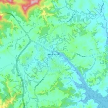
Name: Warkworth topographic map, elevation, terrain.

Location: Warkworth, Rodney, Auckland, 0910, New Zealand (-36.43767 174.62585 -36.35767 174.70585)

Average elevation: 60 m

Minimum elevation: 0 m

Maximum elevation: 329 m

Other topographic maps

Click on a map to view its topography, its elevation and its terrain.

Helensville

New Zealand > Auckland > Rodney

Average elevation: 21 m

Dome Forest

New Zealand > Auckland > Rodney

Average elevation: 168 m

Cowan Bay

New Zealand > Auckland > Rodney > Snells Beach

Average elevation: 22 m

Lake Rototoa

New Zealand > Auckland > Rodney

Average elevation: 102 m

Taupaki Estate

New Zealand > Auckland > Rodney > Kumeū

Average elevation: 37 m

Omaha Beach

New Zealand > Auckland > Rodney > Omaha

Average elevation: 3 m

Gear up for your next adventure:

🦌Outdoor Trail Camera - Monitor wildlife activity near your favorite spots
💡LED Headlamp - Hands-free illumination for night hiking and camping
🏕️Camping Hammock - Integrated protection for sleeping between trees
Lightweight Camping Tent - Portable shelter optimized for Canadian backcountry camping
🧳Compression Sacks - Maximize space in your backpack by shrinking gear

As an Amazon Associate, this site earns from qualifying purchases at no extra cost to you.