
Thank you for supporting this site ❤️
Make a donation
Make a donation
Gear up for your next adventure:
As an Amazon Associate, this site earns from qualifying purchases at no extra cost to you.
Suert topographic map
Click on the map to display elevation.
Thank you for supporting this site ❤️
Make a donation
Make a donation
Gear up for your next adventure:
As an Amazon Associate, this site earns from qualifying purchases at no extra cost to you.
About this map
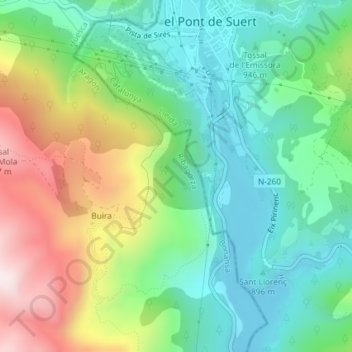
Name: Suert topographic map, elevation, terrain.
Location: Suert, Buira, Bonansa, Ribagorza, Huesca, Aragão, 25520, Espanha (42.38603 0.72660 42.40603 0.74660)
Average elevation: 1,020 m
Minimum elevation: 807 m
Maximum elevation: 1,432 m
Thank you for supporting this site ❤️
Make a donation
Make a donation
Gear up for your next adventure:
As an Amazon Associate, this site earns from qualifying purchases at no extra cost to you.