
Make a donation
Gear up for your next adventure:
As an Amazon Associate, this site earns from qualifying purchases at no extra cost to you.
Distrito de Barú topographic map
Click on the map to display elevation.
Make a donation
Gear up for your next adventure:
As an Amazon Associate, this site earns from qualifying purchases at no extra cost to you.
About this map
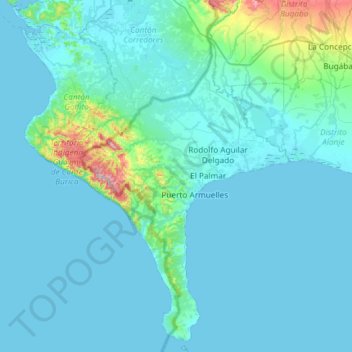
Name: Distrito de Barú topographic map, elevation, terrain.
Location: Distrito de Barú, Chiriquí, Panamá (8.01227 -83.05172 8.59552 -82.70204)
Average elevation: 53 m
Minimum elevation: 0 m
Maximum elevation: 706 m
Make a donation
Gear up for your next adventure:
As an Amazon Associate, this site earns from qualifying purchases at no extra cost to you.
Other topographic maps
Click on a map to view its topography, its elevation and its terrain.
Make a donation
Gear up for your next adventure:
As an Amazon Associate, this site earns from qualifying purchases at no extra cost to you.
Potrero Muleto (Pasto natural) - Cráter antiguo
Panamá > Chiriquí > Distrito Boquete > Palmira
Average elevation: 2,949 m
Make a donation
Gear up for your next adventure:
As an Amazon Associate, this site earns from qualifying purchases at no extra cost to you.
Make a donation
Gear up for your next adventure:
As an Amazon Associate, this site earns from qualifying purchases at no extra cost to you.
Alto de Los Pinos
Panamá > Chiriquí > Distrito Gualaca > Hornito > Valle de Las Minas
Average elevation: 1,024 m
Quijada del Diablo
Panamá > Chiriquí > Distrito Gualaca > Hornito > Valle de Las Minas > Alto de La Mina
Average elevation: 1,195 m
Make a donation
Gear up for your next adventure:
As an Amazon Associate, this site earns from qualifying purchases at no extra cost to you.