Geolocate

Enebyberg topographic map

Click on the map to display elevation.

About this map

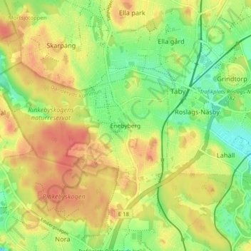
Name: Enebyberg topographic map, elevation, terrain.

Location: Enebyberg, Danderyds kommun, Stockholm County, 182 48, Sweden (59.41123 18.01958 59.45123 18.05958)

Average elevation: 29 m

Minimum elevation: 0 m

Maximum elevation: 54 m

Gear up for your next adventure:

🧤Insulated Winter Gloves - Heavy-duty protection for sub-zero Canadian adventures
🍽️Titanium Camping Spork - Ultralight and indestructible eating utensil
🧥Softshell Hiking Jacket - The perfect balance of wind protection and breathability
🕶️Polarized Sunglasses - Reduces glare from snow and water at high elevations
🩹Moleskin Blister Pads - Direct protection for painful foot pressure points

As an Amazon Associate, this site earns from qualifying purchases at no extra cost to you.