Geolocate

Pohari topographic map

Click on the map to display elevation.

About this map

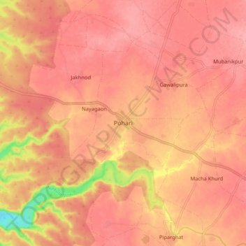
Name: Pohari topographic map, elevation, terrain.

Location: Pohari, Pohri Tahsil, Shivpuri, Madhya Pradesh, 473775, India (25.50019 77.32414 25.58019 77.40414)

Average elevation: 428 m

Minimum elevation: 355 m

Maximum elevation: 450 m

Gear up for your next adventure:

🧳Compression Sacks - Maximize space in your backpack by shrinking gear
🛶Waterproof Dry Bags - Keep electronics and clothes dry during river crossings
🧊Portable Cooler - Keep food and drinks cold during outdoor adventures
🔥Camping Stove - Portable stoves to cook outdoors with ease
🥾Trail Running Boots - Durable shoes designed for trail running

As an Amazon Associate, this site earns from qualifying purchases at no extra cost to you.