Geolocate

Navojoa topographic map

Click on the map to display elevation.

About this map

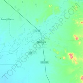
Name: Navojoa topographic map, elevation, terrain.

Location: Navojoa, Sonora, 85870, Mexico (26.91219 -109.60382 27.23219 -109.28382)

Average elevation: 64 m

Minimum elevation: 13 m

Maximum elevation: 499 m

Other topographic maps

Click on a map to view its topography, its elevation and its terrain.

Chirajobampo

Mexico > Sonora > Navojoa

Average elevation: 53 m

Gear up for your next adventure:

🌬️Windproof Camp Stove - Efficient cooking even on exposed mountain peaks
🧰Emergency Multi-Tool - Compact multi-tool for outdoor survival
🥾Light Hiking Boots - Lightweight and comfortable boots for day hikes
🛌Down Sleeping Bag - Superior warmth-to-weight ratio for cold nights
❄️Traction Ice Cleats - Slip-on spikes for icy trails and winter hiking

As an Amazon Associate, this site earns from qualifying purchases at no extra cost to you.