
Docksta topographic map
Interactive map
Click on the map to display elevation.
About this map
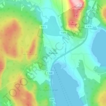
Name: Docksta topographic map, elevation, terrain.
Average elevation: 79 m
Minimum elevation: -1 m
Maximum elevation: 284 m
Other topographic maps
Click on a map to view its topography, its elevation and its terrain.
Skuleberget
Zweden > Västernorrlands län > Vibyggerå distrikt
Skuleberget, Vibyggerå distrikt, Kramfors kommun, Västernorrlands län, 870 33, Zweden
Average elevation: 101 m