
Make a donation
Gear up for your next adventure:
As an Amazon Associate, this site earns from qualifying purchases at no extra cost to you.
Stellberg topographic map
Click on the map to display elevation.
Make a donation
Gear up for your next adventure:
As an Amazon Associate, this site earns from qualifying purchases at no extra cost to you.
About this map
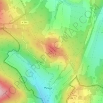
Name: Stellberg topographic map, elevation, terrain.
Average elevation: 560 m
Minimum elevation: 467 m
Maximum elevation: 687 m
Make a donation
Gear up for your next adventure:
As an Amazon Associate, this site earns from qualifying purchases at no extra cost to you.
Other topographic maps
Click on a map to view its topography, its elevation and its terrain.
36452
Deutschland > Thüringen > Landkreis Schmalkalden-Meiningen > Kaltennordheim
Average elevation: 515 m
Fischbach/Rhön
Deutschland > Thüringen > Landkreis Schmalkalden-Meiningen > Kaltennordheim
Average elevation: 508 m
Oberkatz
Deutschland > Thüringen > Landkreis Schmalkalden-Meiningen > Kaltennordheim
Average elevation: 538 m
Kaltenlengsfeld
Deutschland > Thüringen > Landkreis Schmalkalden-Meiningen > Kaltennordheim
Average elevation: 596 m
Make a donation
Gear up for your next adventure:
As an Amazon Associate, this site earns from qualifying purchases at no extra cost to you.
Melpers
Deutschland > Thüringen > Landkreis Schmalkalden-Meiningen > Kaltennordheim
Der Stadtteil Melpers liegt etwa acht Kilometer südlich der Kernstadt Kaltennordheim und drei Kilometer nördlich der Stadt Fladungen an der Grenze von Thüringen nach Bayern. Melpers wird durch Gemeinde Erbenhausen von den anderen Stadtteilen getrennt und bildet somit eine Exklave der Stadt Kaltennordheim.…
Average elevation: 561 m
36452
Deutschland > Thüringen > Landkreis Schmalkalden-Meiningen > Kaltennordheim
Average elevation: 515 m