
Nettersheim topographic map
Click on the map to display elevation.
About this map
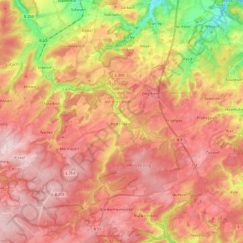
Name: Nettersheim topographic map, elevation, terrain.
Average elevation: 490 m
Minimum elevation: 301 m
Maximum elevation: 606 m
Other topographic maps
Click on a map to view its topography, its elevation and its terrain.
Oberdalmerscheid
Germany > North Rhine-Westphalia > Kreis Euskirchen > Wolfert
Average elevation: 566 m
Weißer Stein City
Germany > North Rhine-Westphalia > Kreis Euskirchen > Udenbreth
Average elevation: 644 m
Rodert
Germany > North Rhine-Westphalia > Kreis Euskirchen > Bad Münstereifel
Average elevation: 382 m