Geolocate

Uchri topographic map

Click on the map to display elevation.

About this map

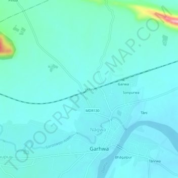
Name: Uchri topographic map, elevation, terrain.

Location: Uchri, Garhwa, Jharkhand, 822114, India (24.15336 83.78507 24.19336 83.82507)

Average elevation: 214 m

Minimum elevation: 190 m

Maximum elevation: 373 m

Gear up for your next adventure:

🧣Merino Neck Gaiter - Protects against wind, sun, and cold at high altitudes
🧥Fleece Jacket - Warm and lightweight jacket for layering
🧦Hiking Socks - Moisture-wicking and comfortable socks for long hikes
🗺️Topographic Maps - Detailed maps to explore trails, mountains, and wilderness areas
💧Hydration Bladder - Hands-free hydration solution for long treks

As an Amazon Associate, this site earns from qualifying purchases at no extra cost to you.