
Huntsville topographic map
Click on the map to display elevation.
About this map
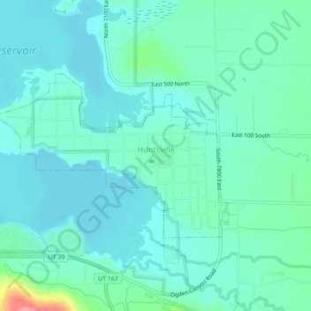
Name: Huntsville topographic map, elevation, terrain.
Location: Huntsville, Weber County, Utah, United States (41.24575 -111.81591 41.27146 -111.75408)
Average elevation: 1,518 m
Minimum elevation: 1,483 m
Maximum elevation: 1,781 m
Other topographic maps
Click on a map to view its topography, its elevation and its terrain.
Eden
United States > Utah > Weber County > Ogden Valley
Eden is a census-designated place in Weber County, Utah, United States. It is home to Powder Mountain ski resort. It lies between the North and Middle Fork of the Ogden River, north of Pineview Reservoir, in the Ogden Valley. The elevation is 4,941 feet (1,506 m). The population was 600 at the 2010 census. It…
Average elevation: 1,562 m
Eden
United States > Utah > Weber County
Eden is a census-designated place in Weber County, Utah, United States. It is home to Powder Mountain ski resort. It lies between the North and Middle Fork of the Ogden River, north of Pineview Reservoir, in the Ogden Valley. The elevation is 4,941 feet (1,506 m). The population was 600 at the 2010 census. It…
Average elevation: 1,562 m