Geolocate

Quevedo topographic map

Click on the map to display elevation.

About this map

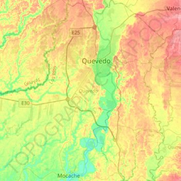
Name: Quevedo topographic map, elevation, terrain.

Location: Quevedo, Los Ríos, Ecuador (-1.19462 -79.61665 -0.93931 -79.36895)

Average elevation: 70 m

Minimum elevation: 27 m

Maximum elevation: 119 m

Other topographic maps

Click on a map to view its topography, its elevation and its terrain.

Los Cedros

Ecuador > Los Ríos > Vinces > Vinces

Average elevation: 25 m

Pepa De Oro

Ecuador > Los Ríos > Puebloviejo > Puebloviejo

Average elevation: 14 m

Sam Augustin

Ecuador > Los Ríos > Valencia > Valencia

Average elevation: 103 m

La Fortuna

Ecuador > Los Ríos > Quinsaloma > Quinsaloma

Average elevation: 94 m

Patria Nueva

Ecuador > Los Ríos > Vinces > Vinces

Average elevation: 16 m

Gear up for your next adventure:

👟Leg Gaiters - Keep debris, mud, and snow out of your boots
🔋Lithium AA Batteries - Long-lasting power that performs in extreme cold
Camping Essentials - All-in-one gear for a comfortable camping trip
🧊Insulated Water Bottle - Keeps drinks cold in summer and prevents freezing in winter
Camping Tent - Weather-resistant tents suitable for 2 to 6 people

As an Amazon Associate, this site earns from qualifying purchases at no extra cost to you.