
Thank you for supporting this site ❤️
Make a donation
Make a donation
Gear up for your next adventure:
As an Amazon Associate, this site earns from qualifying purchases at no extra cost to you.
Bariki topographic map
Click on the map to display elevation.
Thank you for supporting this site ❤️
Make a donation
Make a donation
Gear up for your next adventure:
As an Amazon Associate, this site earns from qualifying purchases at no extra cost to you.
About this map
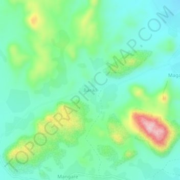
Name: Bariki topographic map, elevation, terrain.
Location: Bariki, Mokolo, Mayo-Tsanaga, Far-North, Cameroon (10.56527 13.81200 10.60527 13.85200)
Average elevation: 666 m
Minimum elevation: 586 m
Maximum elevation: 877 m
Thank you for supporting this site ❤️
Make a donation
Make a donation
Gear up for your next adventure:
As an Amazon Associate, this site earns from qualifying purchases at no extra cost to you.