Geolocate

Valendas topographic map

Click on the map to display elevation.

About this map

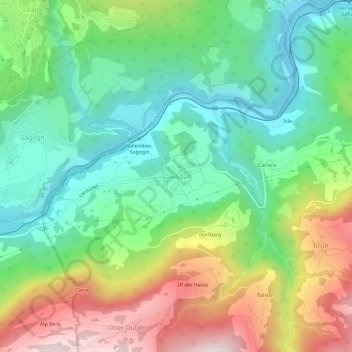
Name: Valendas topographic map, elevation, terrain.

Location: Valendas, Safiental, Surselva, Grisons, 7122, Switzerland (46.76742 9.26159 46.80742 9.30159)

Average elevation: 988 m

Minimum elevation: 632 m

Maximum elevation: 1,620 m

Gear up for your next adventure:

🥽Outdoor Goggles - Protective eyewear for outdoor activities
🥾Hiking Leggings - Comfortable leggings for outdoor activities
🎒Hiking Backpack - Lightweight and ergonomic backpacks for day hikes or multi-day treks
🧭Orienteering Kit - Tools for map reading and navigation in the wild
💡Portable Camping Lamp - Rechargeable lamp for campsite lighting

As an Amazon Associate, this site earns from qualifying purchases at no extra cost to you.