
Make a donation
Gear up for your next adventure:
As an Amazon Associate, this site earns from qualifying purchases at no extra cost to you.
Ecatepec de Morelos topographic map
Click on the map to display elevation.
Make a donation
Gear up for your next adventure:
As an Amazon Associate, this site earns from qualifying purchases at no extra cost to you.
About this map
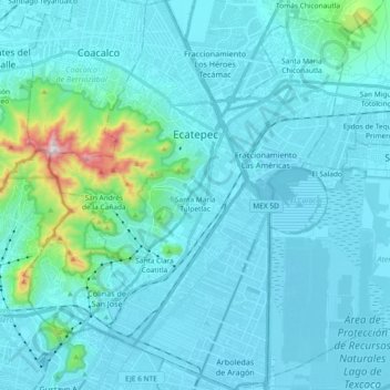
Name: Ecatepec de Morelos topographic map, elevation, terrain.
Location: Ecatepec de Morelos, State of Mexico, Mexico (19.48457 -99.11860 19.65915 -98.97577)
Average elevation: 2,296 m
Minimum elevation: 2,225 m
Maximum elevation: 2,992 m
Make a donation
Gear up for your next adventure:
As an Amazon Associate, this site earns from qualifying purchases at no extra cost to you.
Other topographic maps
Click on a map to view its topography, its elevation and its terrain.
Valle de Bravo
Mexico > State of Mexico > Valle de Bravo
The municipality is surrounded by mountain ranges and other elevated areas covering about 50% of the total area and include the Sierra de Temascaltepec, Sierra de Tenayac, Sierra de Valle de Bravos as wells as the hills that roll around the mountain ranges. These elevations include a number of small volcanoes…
Average elevation: 1,914 m
Make a donation
Gear up for your next adventure:
As an Amazon Associate, this site earns from qualifying purchases at no extra cost to you.