
Thank you for supporting this site ❤️
Make a donation
Make a donation
Gear up for your next adventure:
As an Amazon Associate, this site earns from qualifying purchases at no extra cost to you.
Casamicciola topographic map
Click on the map to display elevation.
Thank you for supporting this site ❤️
Make a donation
Make a donation
Gear up for your next adventure:
As an Amazon Associate, this site earns from qualifying purchases at no extra cost to you.
About this map
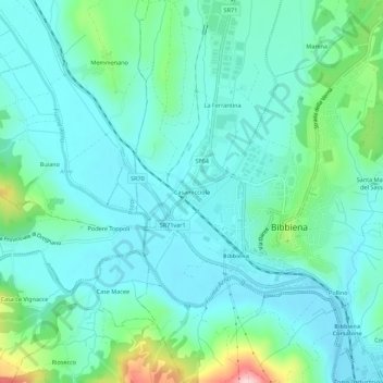
Name: Casamicciola topographic map, elevation, terrain.
Location: Casamicciola, Bibbiena, Arezzo, Toscana, 52011, Italia (43.67921 11.78327 43.71921 11.82327)
Average elevation: 363 m
Minimum elevation: 311 m
Maximum elevation: 577 m
Thank you for supporting this site ❤️
Make a donation
Make a donation
Gear up for your next adventure:
As an Amazon Associate, this site earns from qualifying purchases at no extra cost to you.