Geolocate

Zoverallo topographic map

Click on the map to display elevation.

About this map

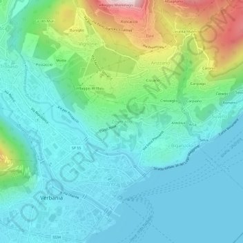
Name: Zoverallo topographic map, elevation, terrain.

Location: Zoverallo, Verbania, Verbano-Cusio-Ossola, Piedmont, 28921, Italy (45.92696 8.55464 45.96696 8.59464)

Average elevation: 322 m

Minimum elevation: 189 m

Maximum elevation: 767 m

Other topographic maps

Click on a map to view its topography, its elevation and its terrain.

Gear up for your next adventure:

💧Filtered Water Bottle - Safe drinking water on the go
🦌Outdoor Trail Camera - Monitor wildlife activity near your favorite spots
🥾Lightweight Hiking Shoes - Comfortable shoes for day hikes
🛶Kayak Accessories - Essential gear for safe and fun kayaking adventures
🧴Sunscreen SPF - Broad-spectrum sunscreen for outdoor activities

As an Amazon Associate, this site earns from qualifying purchases at no extra cost to you.