
Make a donation
Gear up for your next adventure:
As an Amazon Associate, this site earns from qualifying purchases at no extra cost to you.
Almada topographic map
Click on the map to display elevation.
Make a donation
Gear up for your next adventure:
As an Amazon Associate, this site earns from qualifying purchases at no extra cost to you.
Almada
A segunda corresponde à planície litoral da Costa de Caparica, que não excede os 11 metros de cota altimétrica. Apresenta maior largura a norte, constringindo-se gradualmente em direção a sul. A nascente, é delimitada longitudinalmente pela Arriba Fóssil da Costa de Caparica, que também dimunui de altitude em direção a meridião.
Make a donation
Gear up for your next adventure:
As an Amazon Associate, this site earns from qualifying purchases at no extra cost to you.
About this map
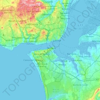
Name: Almada topographic map, elevation, terrain.
Location: Almada, Setúbal, 2800-128, Portugal (38.63643 -9.20500 38.71643 -9.12500)
Average elevation: 32 m
Minimum elevation: -10 m
Maximum elevation: 173 m
Make a donation
Gear up for your next adventure:
As an Amazon Associate, this site earns from qualifying purchases at no extra cost to you.