Geolocate

Donyatt topographic map

Click on the map to display elevation.

About this map

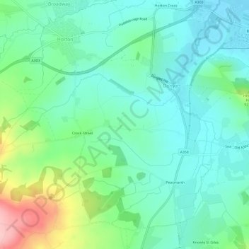
Name: Donyatt topographic map, elevation, terrain.

Location: Donyatt, South Somerset, Somerset, England, United Kingdom (50.90042 -2.97808 50.93182 -2.91939)

Average elevation: 74 m

Minimum elevation: 30 m

Maximum elevation: 198 m

Gear up for your next adventure:

🥾Hiking Shorts - Breathable shorts suitable for summer hikes
🧢Sun Hat - Wide-brim hat for sun protection
Family Camping Tent - Spacious tent suitable for family camping trips
🛶Kayak Accessories - Essential gear for safe and fun kayaking adventures
Backpacking Tent - Lightweight tent for long-distance hiking trips

As an Amazon Associate, this site earns from qualifying purchases at no extra cost to you.