
Fontenay-aux-Roses topographic map
Interactive map
Click on the map to display elevation.
About this map
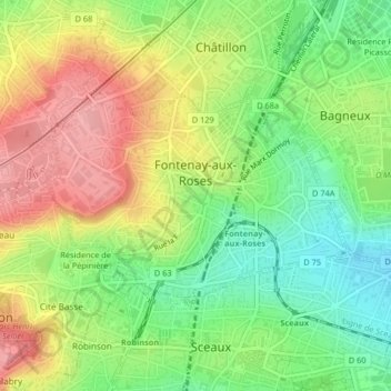
Name: Fontenay-aux-Roses topographic map, elevation, terrain.
Average elevation: 111 m
Minimum elevation: 58 m
Maximum elevation: 170 m
Other topographic maps
Click on a map to view its topography, its elevation and its terrain.
Courbevoie
France > Ile-de-France > Hauts-de-Seine
Courbevoie, Arrondissement of Nanterre, Hauts-de-Seine, Ile-de-France, Metropolitan France, 92400, France
Average elevation: 44 m
Meudon
France > Ile-de-France > Hauts-de-Seine
Meudon, Boulogne-Billancourt, Hauts-de-Seine, Ile-de-France, Metropolitan France, France
Average elevation: 132 m