Geolocate

Kota Belud topographic map

Click on the map to display elevation.

About this map

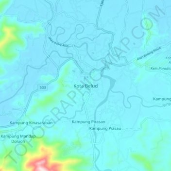
Name: Kota Belud topographic map, elevation, terrain.

Location: Kota Belud, West Coast Division, Sabah, 89158, Malaysia (6.30976 116.38929 6.38976 116.46929)

Average elevation: 41 m

Minimum elevation: 1 m

Maximum elevation: 518 m

Other topographic maps

Click on a map to view its topography, its elevation and its terrain.

Kampung Bayayat

Malaysia > Sabah > Kota Belud

Average elevation: 214 m

Kampung Tiong Kamburaon

Malaysia > Sabah > Kota Belud

Average elevation: 409 m

Kampung Sayap

Malaysia > Sabah > Kota Belud

Average elevation: 511 m

Kampung Melangkap Baru

Malaysia > Sabah > Kota Belud

Average elevation: 286 m

Kampung Lasau Tintapon

Malaysia > Sabah > Kota Belud

Average elevation: 127 m

Kampung Tengkurus

Malaysia > Sabah > Kota Belud

Average elevation: 99 m

Kampung Taginambur

Malaysia > Sabah > Kota Belud

Average elevation: 142 m

Kampung Melangkap Tiong

Malaysia > Sabah > Kota Belud

Average elevation: 311 m

Kampung Kebayau

Malaysia > Sabah > Kota Belud

Average elevation: 277 m

Kampung Tambulion

Malaysia > Sabah > Kota Belud

Average elevation: 30 m

Gear up for your next adventure:

🧼Biodegradable Camp Soap - Environmentally friendly cleaning for gear and body
Lightweight Camping Tent - Portable shelter optimized for Canadian backcountry camping
🧭GPS Outdoor Watch - Smart watch for navigation and fitness tracking in nature
💧Hydration Pack - Hands-free hydration system for long hikes
🧦Hiking Socks - Moisture-wicking and comfortable socks for long hikes

As an Amazon Associate, this site earns from qualifying purchases at no extra cost to you.