Geolocate

Bacacay topographic map

Click on the map to display elevation.

About this map

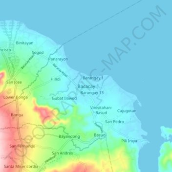
Name: Bacacay topographic map, elevation, terrain.

Location: Bacacay, Albay, Bicol Region, 4514, Philippines (13.25261 123.75125 13.33261 123.83125)

Average elevation: 38 m

Minimum elevation: -2 m

Maximum elevation: 230 m

Other topographic maps

Click on a map to view its topography, its elevation and its terrain.

Peñaranda Park

Philippines > Albay > Legazpi > Baño

Average elevation: 37 m

Malilipot

Philippines > Albay

Average elevation: 262 m

Rapu-Rapu

Philippines > Albay

Average elevation: 18 m

Gear up for your next adventure:

👟Leg Gaiters - Keep debris, mud, and snow out of your boots
🔨Vehicle Emergency Tool - Safety tool for remote road trips to trailheads
🥾Light Hiking Boots - Lightweight and comfortable boots for day hikes
🧥Waterproof Pants - Keep dry during rainy hiking conditions
🚲Bike Repair Kit - Essential tools for on-trail mechanical issues

As an Amazon Associate, this site earns from qualifying purchases at no extra cost to you.