
Dömös topographic map
Interactive map
Click on the map to display elevation.
About this map
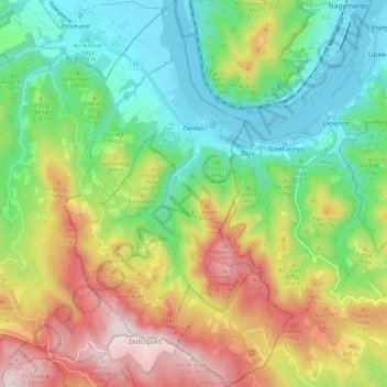
Name: Dömös topographic map, elevation, terrain.
Average elevation: 334 m
Minimum elevation: 100 m
Maximum elevation: 704 m
Other topographic maps
Click on a map to view its topography, its elevation and its terrain.
Rám-szakadék
Rám-szakadék, Téry út, Dömös, Esztergomi járás, Komárom-Esztergom, Central Transdanubia, Transdanubia, 2027, Hungary
Average elevation: 395 m