Geolocate

Uthind topographic map

Click on the map to display elevation.

About this map

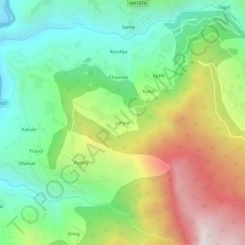
Name: Uthind topographic map, elevation, terrain.

Location: Uthind, Ukhimath, Rudraprayag, Uttarakhand, 246419, India (30.45730 79.08898 30.49730 79.12898)

Average elevation: 1,601 m

Minimum elevation: 967 m

Maximum elevation: 2,633 m

Other topographic maps

Click on a map to view its topography, its elevation and its terrain.

Madmaheshwar

India > Uttarakhand > Ukhimath > Madmaheshwar

Average elevation: 3,160 m

Gear up for your next adventure:

🥾All-Terrain Hiking Boots - Versatile boots for varied hiking conditions
🧥Softshell Hiking Jacket - The perfect balance of wind protection and breathability
Camping Tent - Weather-resistant tents suitable for 2 to 6 people
Backpacking Tent - Lightweight tent for long-distance hiking trips
🥾Trail Running Boots - Durable shoes designed for trail running

As an Amazon Associate, this site earns from qualifying purchases at no extra cost to you.