Geolocate

Alfta topographic map

Click on the map to display elevation.

About this map

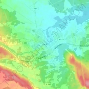
Name: Alfta topographic map, elevation, terrain.

Location: Alfta, Ovanåkers kommun, Gävleborg County, 822 92, Sweden (61.32439 16.03824 61.36439 16.07824)

Average elevation: 121 m

Minimum elevation: 90 m

Maximum elevation: 191 m

Other topographic maps

Click on a map to view its topography, its elevation and its terrain.

Gävle

Sweden > Gävleborg County

Average elevation: 28 m

Disan

Sweden > Gävleborg County

Average elevation: 43 m

Gran

Sweden > Gävleborg County > Gnarp District

Average elevation: 0 m

Ljusdals kommun

Sweden > Gävleborg County

Average elevation: 315 m

Hamra

Sweden > Gävleborg County

Average elevation: 437 m

Hamra

Sweden > Gävleborg County

Average elevation: 437 m

Hudiksvalls kommun

Sweden > Gävleborg County

Average elevation: 95 m

Hamra

Sweden > Gävleborg County

Average elevation: 437 m

Söderhamns kommun

Sweden > Gävleborg County

Average elevation: 67 m

Gnarp District

Sweden > Gävleborg County

Average elevation: 32 m

Gävle kommun

Sweden > Gävleborg County

Average elevation: 61 m

Ovanåkers kommun

Sweden > Gävleborg County

Average elevation: 269 m

Hofors kommun

Sweden > Gävleborg County

Average elevation: 147 m

Gear up for your next adventure:

🧊Insulated Water Bottle - Keeps drinks cold in summer and prevents freezing in winter
🥾Trail Running Shoes - Lightweight and durable shoes for trail running
🔋Solar Power Bank - Keep your GPS and devices charged during long outdoor trips
💡LED Headlamp - Hands-free illumination for night hiking and camping
🗺️Topographic Maps - Detailed maps to explore trails, mountains, and wilderness areas

As an Amazon Associate, this site earns from qualifying purchases at no extra cost to you.