
Могилёв topographic map
Interactive map
Click on the map to display elevation.
About this map
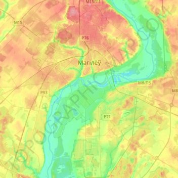
Name: Могилёв topographic map, elevation, terrain.
Location: Могилёв, Oblast Mahiljow, Wit-Rusland (53.79297 30.22618 53.97052 30.47585)
Average elevation: 172 m
Minimum elevation: 136 m
Maximum elevation: 216 m
Other topographic maps
Click on a map to view its topography, its elevation and its terrain.
Химы
Wit-Rusland > Oblast Mahiljow > Бобруйский район > Химовский сельский Совет > Химы
Химы, Химовский сельский Совет, Бобруйский район, Oblast Mahiljow, Wit-Rusland
Average elevation: 156 m
Спартак
Wit-Rusland > Oblast Mahiljow > Тимоновский сельский Совет
Спартак, Тимоновский сельский Совет, Климовичский район, Oblast Mahiljow, Wit-Rusland
Average elevation: 175 m
Хотимский район
Хотимский район, Oblast Mahiljow, 213660, Wit-Rusland
Average elevation: 170 m
Бобруйский район
Бобруйский район, Oblast Mahiljow, Wit-Rusland
Average elevation: 150 m