Geolocate

Lere topographic map

Click on the map to display elevation.

About this map

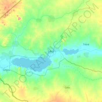
Name: Lere topographic map, elevation, terrain.

Location: Lere, Mayo-Kebbi Ouest, Chad (9.49874 14.06512 9.81874 14.38512)

Average elevation: 298 m

Minimum elevation: 229 m

Maximum elevation: 497 m

Gear up for your next adventure:

🚲Bike Repair Kit - Essential tools for on-trail mechanical issues
🥾Waterproof Hiking Boots - Boots keeping your feet dry in wet conditions
🚲MTB Frame Bag - Carry tools and maps directly on your bicycle frame
📷Outdoor Action Camera - Capture high-elevation views and rugged adventures
🛶Kayak Accessories - Essential gear for safe and fun kayaking adventures

As an Amazon Associate, this site earns from qualifying purchases at no extra cost to you.