Geolocate

Rovescala topographic map

Click on the map to display elevation.

About this map

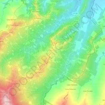
Name: Rovescala topographic map, elevation, terrain.

Location: Rovescala, Pavia, Lombardy, Italy (44.99357 9.31819 45.02741 9.37594)

Average elevation: 210 m

Minimum elevation: 121 m

Maximum elevation: 352 m

Other topographic maps

Click on a map to view its topography, its elevation and its terrain.

Verzate

Italy > Lombardy > Pavia > Torricella Verzate > Verzate

Average elevation: 112 m

Casa Bagnoli

Italy > Lombardy > Pavia > Castana

Average elevation: 179 m

Gear up for your next adventure:

🧴Waterproofing Spray - Restore the DWR coating on jackets and tents
🧴Outdoor Sunscreen - High SPF protection for high-altitude UV exposure
🧦Merino Wool Socks - Moisture-wicking comfort for long-distance hiking
🥾Mountaineering Boots - Supportive boots for climbing and high-altitude hiking
🧤Insulated Winter Gloves - Heavy-duty protection for sub-zero Canadian adventures

As an Amazon Associate, this site earns from qualifying purchases at no extra cost to you.