
Thank you for supporting this site ❤️
Make a donation
Make a donation
Gear up for your next adventure:
As an Amazon Associate, this site earns from qualifying purchases at no extra cost to you.
Burg Aremberg topographic map
Click on the map to display elevation.
Thank you for supporting this site ❤️
Make a donation
Make a donation
Gear up for your next adventure:
As an Amazon Associate, this site earns from qualifying purchases at no extra cost to you.
Burg Aremberg
Die Burg Aremberg bei Aremberg im rheinland-pfälzischen Landkreis Ahrweiler ist die Ruine einer mittelalterlichen Höhenburg auf dem Aremberg im Ahrgebirge (Eifel).
Thank you for supporting this site ❤️
Make a donation
Make a donation
Gear up for your next adventure:
As an Amazon Associate, this site earns from qualifying purchases at no extra cost to you.
About this map
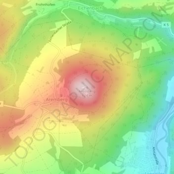
Name: Burg Aremberg topographic map, elevation, terrain.
Average elevation: 438 m
Minimum elevation: 279 m
Maximum elevation: 622 m
Thank you for supporting this site ❤️
Make a donation
Make a donation
Gear up for your next adventure:
As an Amazon Associate, this site earns from qualifying purchases at no extra cost to you.