Geolocate

Wartburg topographic map

Click on the map to display elevation.

About this map
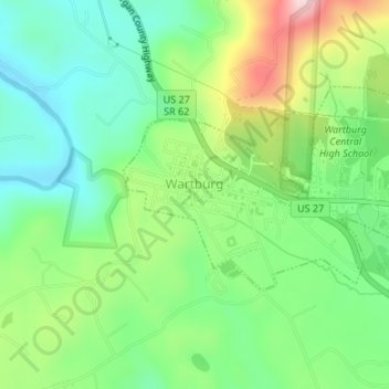
Name: Wartburg topographic map, elevation, terrain.

Location: Wartburg, Morgan County, East Tennessee, Tennessee, United States (36.09657 -84.60347 36.11155 -84.57057)

Average elevation: 404 m

Minimum elevation: 308 m

Maximum elevation: 583 m

Other topographic maps

Click on a map to view its topography, its elevation and its terrain.
Deer Lodge

United States > Tennessee > Morgan County

Average elevation: 466 m

Frozen Head

United States > Tennessee > Morgan County

Average elevation: 763 m

White Oak

United States > Tennessee > Morgan County

Average elevation: 358 m

Stowers

United States > Tennessee > Morgan County

Average elevation: 467 m

Deer Lodge

United States > Tennessee > Morgan County

Average elevation: 466 m

Gear up for your next adventure:

⛺Lightweight Camping Tent - Portable shelter optimized for Canadian backcountry camping
🧶550 Survival Paracord - Versatile utility cord for emergency repairs and rigging
🧭GPS Tracker - Track your location in remote areas safely
🥾Trail Running Boots - Durable shoes designed for trail running
🧼Biodegradable Camp Soap - Environmentally friendly cleaning for gear and body

As an Amazon Associate, this site earns from qualifying purchases at no extra cost to you.