
Make a donation
Gear up for your next adventure:
As an Amazon Associate, this site earns from qualifying purchases at no extra cost to you.
Thaler Höhe topographic map
Click on the map to display elevation.
Make a donation
Gear up for your next adventure:
As an Amazon Associate, this site earns from qualifying purchases at no extra cost to you.
Thaler Höhe
Die Thaler Höhe ist ein 1167 m ü. NHN hoher Nebengipfel der Salmaser Höhe in den Allgäuer Alpen oder wahlweise im Bayerischen Alpenvorland, da die beiden Naturräume nicht einheitlich voneinander abgegrenzt werden. Sie liegt im Landkreis Oberallgäu in der Gemarkung der Gemeinde Missen-Wilhams.
Make a donation
Gear up for your next adventure:
As an Amazon Associate, this site earns from qualifying purchases at no extra cost to you.
About this map
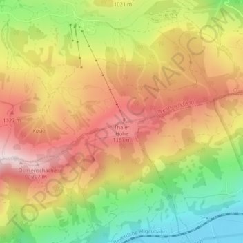
Name: Thaler Höhe topographic map, elevation, terrain.
Average elevation: 990 m
Minimum elevation: 724 m
Maximum elevation: 1,224 m
Make a donation
Gear up for your next adventure:
As an Amazon Associate, this site earns from qualifying purchases at no extra cost to you.