Geolocate

Bolingbrook topographic map

Click on the map to display elevation.

About this map

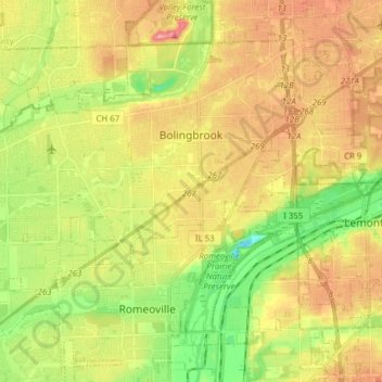
Name: Bolingbrook topographic map, elevation, terrain.

Location: Bolingbrook, Will County, Illinois, United States (41.63077 -88.17967 41.73582 -88.02516)

Average elevation: 207 m

Minimum elevation: 149 m

Maximum elevation: 269 m

Other topographic maps

Click on a map to view its topography, its elevation and its terrain.

Drummond

United States > Illinois > Will County

Average elevation: 167 m

Puddle Pond

United States > Illinois > Will County > Plainfield

Average elevation: 187 m

Arbury Hills

United States > Illinois > Will County

Average elevation: 216 m

Gear up for your next adventure:

🍽️Titanium Camping Spork - Ultralight and indestructible eating utensil
🥾Trail Hiking Socks - Comfortable socks to prevent blisters and fatigue
🔋Emergency Crank Radio - Weather alerts and power without needing batteries
🥾Waterproof Hiking Boots - Essential footwear for rugged terrain and wet Canadian trails
🧴Bear Spray Holster - Quick-access carry for essential Canadian wilderness safety

As an Amazon Associate, this site earns from qualifying purchases at no extra cost to you.