
Thank you for supporting this site ❤️
Make a donation
Make a donation
Gear up for your next adventure:
As an Amazon Associate, this site earns from qualifying purchases at no extra cost to you.
Puertecitos topographic map
Click on the map to display elevation.
Thank you for supporting this site ❤️
Make a donation
Make a donation
Gear up for your next adventure:
As an Amazon Associate, this site earns from qualifying purchases at no extra cost to you.
About this map
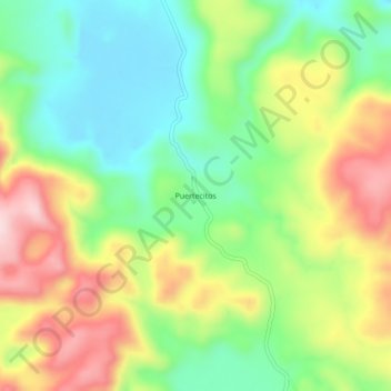
Name: Puertecitos topographic map, elevation, terrain.
Location: Puertecitos, Santa Catarina, San Luis Potosi, Mexico (21.64004 -99.40841 21.68004 -99.36841)
Average elevation: 489 m
Minimum elevation: 363 m
Maximum elevation: 669 m
Thank you for supporting this site ❤️
Make a donation
Make a donation
Gear up for your next adventure:
As an Amazon Associate, this site earns from qualifying purchases at no extra cost to you.