Geolocate

Carina topographic map

Click on the map to display elevation.

About this map

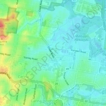
Name: Carina topographic map, elevation, terrain.

Location: Carina, City of Brisbane, Queensland, Australia (-27.50073 153.08522 -27.47372 153.12082)

Average elevation: 18 m

Minimum elevation: -3 m

Maximum elevation: 66 m

Other topographic maps

Click on a map to view its topography, its elevation and its terrain.

Bulimba Creek

Australia > Queensland > City of Brisbane

Average elevation: 11 m

Tangalooma

Australia > Queensland > City of Brisbane

Average elevation: 41 m

Enoggera Hill

Australia > Queensland > City of Brisbane

Average elevation: 114 m

Enoggera Dam

Australia > Queensland > City of Brisbane

Average elevation: 90 m

Blunder Creek

Australia > Queensland > City of Brisbane

Average elevation: 26 m

Tangalooma

Australia > Queensland > City of Brisbane

Average elevation: 41 m

Gear up for your next adventure:

🔦LED Flashlight - Powerful and long-lasting flashlight for camping and emergencies
💧Hydration Pack - Hands-free hydration system for long hikes
🛶Kayak Dry Bag - Waterproof storage for kayaking adventures
🧰Emergency Multi-Tool - Compact multi-tool for outdoor survival
🧰Multitool Knife - Compact and versatile tool for outdoor use

As an Amazon Associate, this site earns from qualifying purchases at no extra cost to you.