Geolocate

Para topographic map

Click on the map to display elevation.

About this map

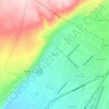
Name: Para topographic map, elevation, terrain.

Location: Para, Tacna, 23006, Perú (-18.05099 -70.31085 -18.01099 -70.27085)

Average elevation: 531 m

Minimum elevation: 399 m

Maximum elevation: 737 m

Other topographic maps

Click on a map to view its topography, its elevation and its terrain.

Urbanización Bacna Ríos

Perú > Tacna > Tacna

Average elevation: 581 m

Óvalo Cristo Rey

Perú > Tacna > Tacna

Average elevation: 504 m

Gear up for your next adventure:

🔦LED Flashlight - Powerful and long-lasting flashlight for camping and emergencies
🧥Packable Rain Jacket - Breathable waterproof layer for unpredictable weather
Camping Essentials - All-in-one gear for a comfortable camping trip
🕶️Polarized Sunglasses - Protect your eyes with durable polarized lenses
🧴Sunscreen SPF - Broad-spectrum sunscreen for outdoor activities

As an Amazon Associate, this site earns from qualifying purchases at no extra cost to you.