Geolocate

Clyde River topographic map

Click on the map to display elevation.

About this map
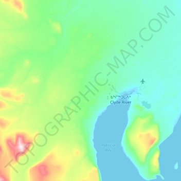
Name: Clyde River topographic map, elevation, terrain.

Location: Clyde River, Qikiqtaaluk Region, Nunavut, Canada (70.37628 -68.83233 70.57968 -68.28610)

Average elevation: 136 m

Minimum elevation: 0 m

Maximum elevation: 840 m

Other topographic maps

Click on a map to view its topography, its elevation and its terrain.

Mount Asgard

Canada > Nunavut > Qikiqtaaluk Region

Average elevation: 1,201 m

Arctic Bay

Canada > Nunavut > Qikiqtaaluk Region

Arctic Bay experiences a tundra climate (Köppen: ET) like most northern Canadian territories at low elevations, with long, very cold winters and short, cool to cold summers. July is the only month with an average low temperature above freezing. Its climate does not differ from the more severe subarctic…

Average elevation: 160 m

Fellfoot Point

Canada > Nunavut > Qikiqtaaluk Region

Average elevation: 2 m

Horizon Hill

Canada > Nunavut > Qikiqtaaluk Region

Average elevation: 139 m

Bjorne Peninsula

Canada > Nunavut > Qikiqtaaluk Region

Average elevation: 155 m

Cape Rosamond

Canada > Nunavut > Qikiqtaaluk Region

Average elevation: 3 m

Gear up for your next adventure:

🧦Outdoor Socks - Durable socks designed for hiking and outdoor sports
🎒Backpack Rain Cover - External shield to keep your entire pack dry
🥫Freeze-Dried Meals - Lightweight, high-calorie nutrition for multi-day treks
💡Compact LED Flashlight - Powerful and portable flashlight for outdoor use
🕶️Polarized Sunglasses - Protect your eyes with durable polarized lenses

As an Amazon Associate, this site earns from qualifying purchases at no extra cost to you.