Geolocate

Giralba topographic map

Click on the map to display elevation.

About this map

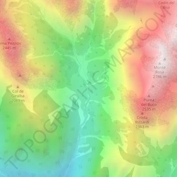
Name: Giralba topographic map, elevation, terrain.

Location: Giralba, Auronzo di Cadore, Belluno, Veneto, 32041, Italy (46.59537 12.39557 46.59597 12.39579)

Average elevation: 1,806 m

Minimum elevation: 997 m

Maximum elevation: 2,730 m

Other topographic maps

Click on a map to view its topography, its elevation and its terrain.

Stabiziane

Italy > Veneto > Belluno > Auronzo di Cadore

Average elevation: 1,460 m

Misurina

Italy > Veneto > Belluno > Auronzo di Cadore

Average elevation: 1,954 m

Misurina

Italy > Veneto > Belluno > Auronzo di Cadore

Average elevation: 1,954 m

Gear up for your next adventure:

🧭GPS Tracker - Track your location in remote areas safely
🛶Kayak Accessories - Essential gear for safe and fun kayaking adventures
💧Filtered Water Bottle - Safe drinking water on the go
🧴Waterproofing Spray - Restore the DWR coating on jackets and tents
🔦UV Flashlight - Detect minerals or specific insects in the dark

As an Amazon Associate, this site earns from qualifying purchases at no extra cost to you.